Monday, December 26, 2016

ENERGY FLOW THROUGH ECOSYSTEMS

Solar energy powers all life processes on Earth

Solar energy captured during the light-dependent reaction of photosynthesis is the ingredient that powers most ecosystem processes.  This energy is passed from trophic level to trophic level, fueling the emergence of virtually all life forms on Earth.  Energy is the theme of the next video in the AP Environmental Science topic of The Living World.  It is available through the publishing partner of Bird Conservation Research, Inc.: Arts and Academic Publishing.

The video begins by exploring climatic relationships among biomes through climatographs.  It then moves to a discussion of the light and dark reactions of photosynthesis and how these processes are used in producing living biomass.  It next considers the laws of thermodynamics and how these constrain energy flow through ecosystems.  Concepts relating to productivity are then reviewed, as is the transfer of energy through trophic levels.  The video concludes by following energy from primary producers to consumers to decomposers.

Sunday, December 18, 2016

WETLAND BIOMES

The rocky intertidal zone of the Rhode Island coast is one of the topics considered in the next video in the Living World series.

In addition to terrestrial biomes, aquatic biomes are also recognized.   Those examined in the next video in the Living World lecture series of Arts and Academic Publishing include estuaries and their vegetated wetlands, including salt marshes and mangrove swamps.  Wildlife of estuarine wetlands are distinctive, and include species like the Seaside and Sharp-tailed sparrows.  Adaptations of these species for the stressful physical conditions of the estuary are considered.

Marine ecosystems are explored next, and investigate the habitats that make them up.  These include the intertidal realm, benthic environments and pelagic environments.  These environments are further subdivided into zones, and the characteristics of each are considered.  All these topics related to the National AP Environmental Science curriculum.


Wednesday, November 30, 2016

ALPINE ZONATION AND RELICT COMMUNITIES

Forest gives way to alpine tundra at the highest elevations of the Rocky Mountains.
The next video in the Living World lecture series of Arts and Academic Publishing (the publishing partner of Bird Conservation Research, Inc.) extends its discussion of terrestrial biomes by considering the effects of altitude on the occurrence of biomes. Alpine zonation, as it is called, refers to the appearance of increasingly northern-associated biomes as altitude increases. The video explores the zonation that occurs in the southern Appalachian Mountains, from temperate seasonal forest in the lowlands to boreal forest at the highest elevations. A version of krummholz vegetation even occurs on the highest peaks. In the northern Appalachians and Rocky Mountains, alpine tundra can be found.

A phenomenon related to alpine zonation is that of relict communities- pockets of plant communities that occur much further south than they occur at present.  These communities may still occupy land that they inhabited when global climate was different than it is today. In colder microclimates, such as those found in southern New England bogs, spruce-larch associations typical of the far north still occur well south of their present range. Locally endemic species are often found in such locations, and their occurrence can be related to re-colonization events that followed the close of the last glacial era.

This video is compatable with the AP Environmental Science curriculum.


Monday, November 14, 2016

SUBTROPICAL SAVANNAH, SHRUBLAND AND DESERT

The oak savannah of northern California is first cousin to the shrublands of the southern parf of the state.

The next three biomes covered in the Living World video lecture series of Arts and Academic Publishing include subtropical savannah, shrubland and desert.  These videos are compatible with the AP Environmental Science curriculum.

The examination of subtropical savannah focuses on the Kissimmee Prairie region of southern Florida, and considers its flora and the role of animals in sustaining this ecosystem.  It also examines its endemic fauna, including such species as the Caracara.  Exploration of the shrubland biome centers on the San Gabriel Mountains of southern California.  It considers the annual distribution of rainfall and the role of fire in sustaining this ecosystem.  It also considers the oak savannah of northern California and how this environment relates to these two biomes.  The video then crosses the southern California mountains and examines the high desert ecosystem that develops to the east in the rain shadow of these mountains.  It highlights the Joshua trees of the wetter portions of this desert, and also investigates animal species like the Gopher Tortoise and Spadefoot Toad and the adaptations that they possess for living in this environment.

Saturday, November 5, 2016

WHERE THE BUFFALO ROAM

The shortgrass prairie habitat of the American Bison is featured in this video.
In its tour through AP Environmental Science topics, the next installment of the Living World video series focuses on three additional biomes.  It begins by examining temperate grasslands, and explores the physical environmental factors that favor the development of grassland environments- continental climate, limited rainfall and wildfires.  It also explores the relationship between perennial grassland vegetation and the animal species it supports, notably the American Bison, Pronghorn Antelope and Black-tailed Prairie Dog.

The focus then shifts to rainforest environments, first temperate rainforests and then tropical.  It compares and contrasts these, illustrating the coniferous nature of the temperate systems and the vast diversity of broadleaf vegetation that fills tropical systems.  In both environments, abundant moisture produces trees of great size, although the longevity of temperate rainforest giants is unsurpassed.  The video concludes by depicting the bird life of both systems, highlighting in particular the specializations employed by the diverse avifaunas of tropical rainforest.


This video, like all in the series, is available through Arts and Academic Publishing, the publishing partner of Bird ConservationResearch, Inc.

Monday, October 24, 2016

COMPLETE BIOME VIDEOS

The subalpine fir forests of the Wasatch Mountains in Utah are examples of alpine boreal forest.

The topic of biomes is a major one in the AP Environmental Science curriculum.  To document the characteristics of the world's major biomes, Arts and Academic Publishing has prepared a series of videos.  The first in this series explores the concept of biomes and the roles of climate, topography and edaphic factors in determining the geographic distribution of these major subdivisions of Earth's surface.  It then goes on to examine four terrestrial biomes: tundra, boreal forest, temperate seasonal forest and temperate grasslands.  For each of these four, the prevailing plant life, limiting factors, climate and animal life are reviewed.

Arts and Academic Publishing is the publishing partner of Bird Conservation Research, Inc.  BCR offers a variety of free laboratory activities, videos, PowerPoints and publications also suitable for the AP Environmental Science curriculum.

Tuesday, October 18, 2016

SPECIES COMPETITION AND ESKIMO CURLEWS

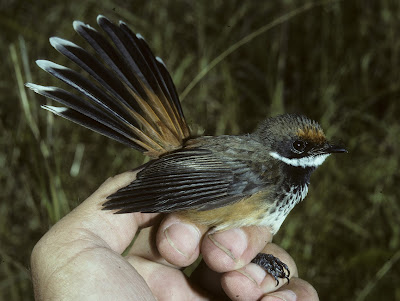
The Rufous Fantail of the tropical Pacific competes with the larger Tinian Monarch
Another of the videos in the environmental science series that is available through our internet publishing partner, Arts and Academic Publishing is entitled Species Competition. It begins by exploring community assembly: how it is that particular physical environments come to be occupied by particular groups of species. It then examines how species within such communities might come into competition for such resources as food and living space. The video then goes on to explore ideas about discrete communities as opposed to communities of environmental gradients, where assemblages of species gradually pass from one to another. It examines in more detail the types of environmental gradients that occur along an ordinary New England wooded hillside. The video goes farther afield in examination of niche overlap and instances of inter– and intra-specific competition, looking at examples not only from New England but also from tropical regions.

This is one of several topics covered in the latest Bird Conservation Research newsletter.  In addition, it reports the latest news on the forest bird survey of southern New England and on the ongoing search for the Eskimo Curlew.

Monday, September 19, 2016

DOES COEXISTENCE EQUAL COMPETITION?


Not necessarily and, in fact, maybe not usually, especially in the temperate zone.  In this first video in the series The Living World (which follows the AP Environmental Science curriculum), the construction of an ecological community is explored.  It begins by exploring the curious case of the Louisiana (above) and Northern waterthrushes, which despite being exceedingly similar in what they do and where they live, down to even nesting in the same upturned root of the same tree, do not exhibit any appreciable interspecific competition.  The issue is that there must be something to compete over, and in this case particularly food has been found to be in abundance. 

The video reviews the concept of the ecological niche and discusses the categories and components of the niche.  It further relates this concept to more typical pairs of species that, although related to each other, exhibit ecological differences that place them into separate niches.  It examines how species within a community can differ from one another along single and multiple resource axes. 

It also investigates how communities can change seasonally, with individual species changing their distributions and habitat use seasonally.  It concludes by exploring how communities are affected by habitat size, and discusses the species-area effect and what sorts of phenomena can lead to this effect.

As with other videos in this series, it is available through Arts and Academic Publishing- the publishing partner of Bird ConservationResearch, Inc.


Tuesday, September 6, 2016

WHY DO PLANTS HAVE COLORS?


Why do plants have colors?  Why do some plants grow in certain places and not others?  It has to do in large part with the properties of the soil that the plants grow in.  In the video Earth Systems and Resources: Soil Properties, which follows the national AP Environmental Science curriculum, these issues are investigated.  In many instances, soil micronutrients are responsible for phenomena like color and presence/ absence, but soil structure, soil particle size, slope and the interaction of plants and mineral soil can further influence these.  Hence, topics like soil horizons, soil textures and macro- vs. micronutrients, are also explored in the video. 

Soil nutrients are explored in particular detail.  For example, each nutrient is responsible for certain functions, with elements like iron being involved in the functioning of the electron transport system and calcium being involved in the permeability of the cell membrane.  Moreover, various soil types have differing capacities to exchange nutrients with plants.  Coarser soils tend to have poorer abilities to hold and exchange nutrients than do soils with clays as components.

The video also explores the issue of soil water.  Again, soils of different textures have varying abilities to retain water, with soil pore size influencing this capacity.


As with other videos in this series, it is available through Arts and Academic Publishing- the publishing partner of Bird ConservationResearch, Inc.

Tuesday, August 9, 2016

ENVIRONMENTAL SCIENCE VIDEO SERIES: SOIL AND WATER RESOURCES

The Portland, Connecticut floodplain of the Connecticut River experiencing a spring flood.
The sixth video under the heading of Earth Systems and Resources begins by examining the effects of dikes on major rivers in directing flooding to more downriver areas.  This redirection potentially increases the degree of flooding at downriver points.  The video then examines the concepts of aquifers, aquifer recharge and aquifer depletion, and discusses how in coastal areas aquifer depletion can lead to salt water intrusion.  The topic of water resources is concluded by reviewing major global problems that water conservationists face and exploring conservation solutions to some of these problems.

The video then shifts focus to soil resources and begins by discussing the major categories of rocks, their methods of formation, the chemistry of rocks and the rock cycle.  Special attention is given to the formation of coal.  To conclude the video, the roles of wind and water erosion are explored in relation to producing categories of soil particles.


As with other videos in this series, it is available through Arts and Academic Publishing- the publishing partner of Bird ConservationResearch, Inc.

Thursday, July 28, 2016

CONNECTICUT’S LAST VIRGIN FOREST


The tree stumps so prominent in my 1976 plot were now gone without a trace.  They were leftovers from the 1938 hurricane, which passed nearly over this low hill bordering Connecticut and Rhode Island.  Until that time, the site had been cloaked in a stand of old growth that had never been logged, although storms like the 1815 hurricane had similarly taken their toll, as evidenced by growth rings on stumps recorded by Harvard botanist Hugh Raup shortly after the 1938 storm.  These were still visible to me 38 years later.  It was the last forest in Connecticut with any claim of being virgin although, to be sure, it was one with a dynamic history of growth, disturbance and regeneration.

I first visited this site in July of 1976, when I was quantitatively analyzing Connecticut’s newly defined critical habitats.  The site had grown up to a dense, even-aged stand of young trees, most of which could trace their beginning to 1938.  During my investigation, the prevailing forest cover was of trees just under 40 years old and with an average diameter at breast height (dbh) of 18 cm.  Except- all the old trees had not been blown down.  There were still a handful of much bigger trees that had clearly started growing long before that time.  There was a monumental sassafras with a 62.3 cm dbh - two feet across- quite something for a tree that typically appears in southern New England forests as a scrawny understory tree. There was also a mammoth white oak with a dbh of 86.6 cm- approaching three feet in diameter- a black oak of 53.3 cm dbh, a red maple of 72.9 cm dbh and a ‘red’ pignut hickory of 72.9 cm dbh.

To characterize this site and to provide a baseline for future investigation, I established a 10 x 20 m plot that was clearly delineated by the presence of a massive boulder at its northeast corner (remember, these were the days before GPS).  I found 11 canopy trees of three species that had a mean diameter of 25.9 cm.  The giant sassafras was the largest of them.  Saplings included the same species found in the canopy: white oak, black oak and sassafras, although it appeared that red maple might grow in importance as a canopy tree. The site was also a very xeric one, with a shrub layer dominated by a dense stand of huckleberry. 

This brings us to today- 28 July 2016- when I again visited the site and re-surveyed my old plot, still easily distinguishable from the presence of the boulder and immense sassafras.  Over the intervening 40 years, the forest had changed, with only seven canopy trees now averaging 37.4 cm dbh being present.  One of these was indeed a red maple of 18.1 cm dbh- a 1976 understory tree that had, as predicted, invaded the canopy.  Furthermore, the old sassafras, although still an imposing presence within the plot, was recently dead, with its uppermost branches now carpeting the forest floor.  The shrub layer was still strongly dominated by huckleberry, although the tall blueberry I had identified in the plot turned out to be Vaccinium atrococcum rather than the V. corymbosum I had mistaken it for in 1976- silly me; the latter is a wetland shrub, as I knew, and this was no wetland.  The former is much more of an upland species in southern New England.

In general, the canopy of the site as a whole had greatly thinned and now resembled that of typical mature forests in the region.  Indeed, with a present prevailing canopy age of about 80 years, it should .  As I investigated the vicinity, I found a number of substantial tree specimens.  I measured 22, which had an average dbh of 62.2 cm compared with 49.9 cm dbh for 24 trees in 1976.  The largest was now an 83.9 cm dbh red maple.

I have now lived long enough to witness first hand the process of forest succession- not inferred it from forest stands of different ages, but directly observed it by examining the same plot over a very long series of years.  This raises an issue: this site, with its long and periodically catastrophic history, does indeed represent a virgin stand despite not looking terribly different than a hundred others in the vicinity.  Periodic disruption is part of the natural process that keeps this woodland in a state of more or less dynamic equilibrium.  Fortunately for those of us interested in such things, it is now owned by a land trust, so we can continue to follow its evolution for decades to come.

Robert J. Craig

Sunday, July 24, 2016

ENVIRONMENTAL SCIENCE VIDEO SERIES: SEASONALITY AND ATMOSPHERICS

The southern Appalachians in April show the advance of seasons from flowering spring trees in valleys to the wintery spruce-fir forests of high elevations.


The forth full episode in the video series that covers all topics in the national AP Environmental Science curriculum is entitled Seasonality and Atmospherics.  It opens with a discussion on seasonality and points out that temperate and tropical seasons differ.  Moreover, it demonstrates that altitude affects the passage of seasons in the temperate zone, with higher elevations having the advance of spring retarded (see photo above).  It relates the occurrence of seasonality to the tilt of the Earth's axis with respect to the sun.  

The video then proceeds to describe the physical and chemical nature of the atmosphere and contrasts the early Earth atmosphere with its present condition.  The role of photosynthetic organisms in shaping the present atmosphere is emphasized, and the vertical structure of the atmosphere is identified.  The video ends with a comparison and contrast of weather and climate.

The video is offered through Bird Conservation Research's new publishing partner, Arts and Academic Publishing, who's web site is now fully functional.  Arts and Academic is now also seeking academic manuscripts for review and publication.  See their web site for details.

Friday, July 1, 2016

THE REMAINS OF A CONNECTICUT GRASSLAND: A FORTY YEAR HISTORY


The switchgrass-sedge grassland of Great Meadow is now largely invaded by cattails and reeds.

The birds were actually better this time around.  In June of 1976, pickings at Great Meadows in Essex, Connecticut were a bit slim, with gulls being among the most abundant species present.  Aside from the ubiquitous Common Yellowthroats, Swamp Sparrows, Marsh Wrens and lone Bobwhite, there was not much of interest present.  In contrast, during this June of 2016, gulls were uncommon and Bobwhites had disappeared, but multiple Ospreys were nesting and several Purple Martins flew overhead.  Both were all but absent in earlier years.  Great Egrets, confined to the river mouth in the 1970s, were also now conspicuously present, as were Rough-winged Swallows, which had replaced formerly common Bank Swallows.  To round things out, a Spotted Sandpiper fed along the banks of the adjacent Connecticut River and a Common Tern explored the river and adjacent tidal creeks.

Forty years have now passed since my first investigation of this extensive lowland bordering the lower Connecticut River.  I had initially gone there to study the extended ecotone between the site’s weakly brackish marsh and adjacent upland.  I thought the wet, grassy meadow that developed there was about as close as southern New England could come to having an extensive natural grassland, and I wanted to document its nature so that I might determine its persistence over time.  Toward that end, I inventoried the entire site and also established a study plot to quantify the presence of key community members.  My plot, chosen to be representative of the site as a whole (although I noted that there was a gradient in species composition from the north to south end), demonstrated that the predominant species were switchgrass (Panicum virgatum), a short species of bulrush- Scirpus americanus, and a sedge- Eleocharis palustris.  In all, I found 11 herbaceous species occupying the 100 m2 plot. 

In 1983, I re-visited the meadow and observed that the community was much as it had been seven years before.  However, during this 2016 survey, I found that the ecotone had changed dramatically, with cattails and reeds invading much of it.  Furthermore, S.  americanus now appeared to be present primarily along the edge of the Connecticut River.  This observation left me perplexed enough that I began to doubt my initial identification, but upon later examining specimens I had collected both in 1976 and 1983, I found that my initial determination had been correct.  In the place of this species, I found that the sedges S. fluviatilis, S. atrovirens and the forb Peltandra virginica had become widespread.  I had recorded these species on my 1976 surveys, but none had occurred in the study plot, indicating that they were less common than now.  Switchgrass, although still present, was also not nearly as common as it had once been.  Even into 1983, I was still describing the site as a Panicum meadow, but this characterization no longer held.  Moreover, the entire meadow itself had shrunk from about 6 ha in 1976 to about two ha at present.  All these changes suggested that the site had become wetter over time, with the new dominant species t.ypical of emergent marsh rather than upland ecotone.  Human manipulation in the form of expanded mowing further assisted with reducing the meadow’s extent and, indeed, portions of the meadow have in the past been mowed for hay.

So what is to be gleaned from such long-term observations?  Well, first of all, I’ve concluded that my initial characterization of the meadow as a wet, albeit upland grassland was a bit generous.  With the benefit of now having examined all of the major herbaceous wetlands of the lower Connecticut River for decades, I think that it is more reasonable to characterize such meadows as simply vegetation zones within larger marsh ecosystems.  Furthermore, it now is clear that such communities are not static entities, but are rather dynamic associations that change over time in response to changing physical and competitive environment as as well as to human manipulation.

Alas, the notion of naturally persistent grasslands in southern New England is for me one that has become progressively harder to believe in.  We might still hold out some hope for the reed-canary grass (Phalaris arundinacea) ecotones of more completely freshwater marshes further inland, as Phalaris appears to be aggressively competitive with other species.  However, here again, it seems more reasonable to characterize such habitats as simply marsh vegetation zones rather than upland systems.  I suppose dune grass communities of the coast, nominal though they are, hold the only real claim for being naturally persistent southern New England grasslands.